
Table of Contents
General Introduction of India
The official name of IndiA is the Republic of India. India is the second-most populated country in the world and also the seventh- largest country by land in the world. The Republic of Indiα is made up of twenty-eight states and eight union territories. New Delhi is the National Capital Territory of Indiα.
Below the table shown are general information about Indiα.
Flag |
|
Capital | New Delhi |
Official Languages | Hindi and English |
Recognized Regional languages | 22 (Assamese, Bengali, Bodo, Dogri, Gujarati, Hindi, Kannada, Kashmiri, Konkani, Maithili, Malayalam, Manipuri, Marathi, Nepali, Odia, Punjabi, Sanskrit, Santali, Sindhi, Tamil, Telugu, Urdu) |
Government | Quasi-Federal Republic |
President | Ram Nath Kovind |
Vice-president | Venkaiah Naidu |
Prime Minister | Narendra Damodardas Modi |
Chief Justice | N. V. Ramana |
Lok Sabha Speaker | Om Birla |
Legislature | Bicameral Parliament |
Upper House | Rajya Sabha |
Number of members in the Upper House | 245 (233 Elected + 12 Nominated) |
Lower House | Lok Sabha |
Number of members in the Lower House | 543 |
Independence Day | 15 August 1947 |
Republic Day | 26 January 1950 |
Population | 2nd rank in the world (Approximately, 136.64 crores in 2019 according to the World Bank) |
Currency | Indiαn rupee (₹) |
Time Zone | UTC+05:30 (Indian Standard Time) |
Date Format | dd-mm-yyyy |
Calling Code | +91 |
Geographical Introduction of India
Indiα is a part of the Asia Continent. It is situated on the western fringe of the Indian Ocean. Indiα lies midway between South East Asia and the South West Asia. Indiα shares land borders with Pakistan to the west, Afghanistan to the northwest, China, Nepal, and Bhutan to the north and Myanmar and Bangladesh to the east.
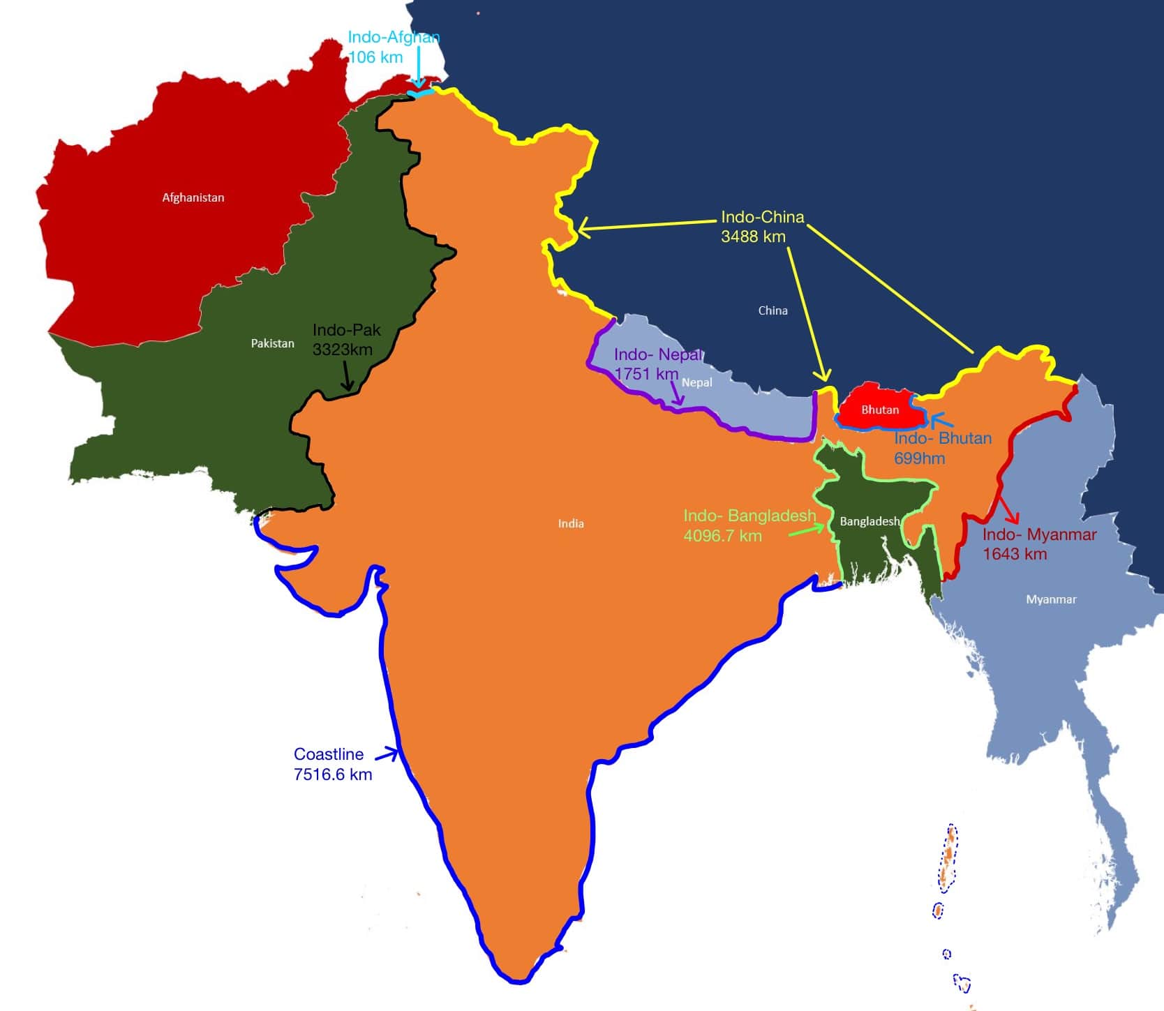
Below the table shown the length of the borders of the neighbouring countries of Indiα.
Country | Length (in km.) | Longest bordered states | |
1. | Bangladesh | 4096.7 | West Bengal |
2. | China | 3488 | Ladakh (U.T.) |
3. | Pakistan | 3323 | Rajasthan |
4. | Nepal | 1751 | Bihar |
5. | Myanmar | 1643 | Mizoram |
6. | Bhutan | 699 | Assam |
7. | Afghanistan | 106 | Ladakh (U.T.) |
The Indian Peninsula coastal line is surrounded on three sides by Oceans, i.e., the Bay of Bengal to the southeast, the Indian Ocean to the south and the Arabian sea to the southwest.
India shares its maritime border with Sir Lanka and Maldives in the Indian Ocean. Also, in the Indian Ocean, the Indiαn Islands Andaman and Nicobar share maritime borders with Thailand, Myanmar and Indonesia. However, Pakistan, Bangladesh and Myanmar are the countries that share land borders as well as water borders with India.
Below the table shown are geographical information about India.
Continent | Asia |
Region | Indian subcontinent (South Asia) |
Latitude | 8˚4′ N to 37˚6′ N |
Longitude | 68˚7′ E to 97˚25′ E |
Area | 32,87,263 sq. km |
Land | 91% |
Water | 9% |
Land Frontier | 15,200 km |
Coastline | 7516.6 km (mainland including Andaman Nicobar and Lakshadweep) |
North-South Extent | 3214 km |
East-West Extent | 2933 km |
Standard Meridian | 82˚30′ East Longitude |
Southernmost Point | Indira point (Nicobar Island) |
Southernmost point of mainland | Cape Comorin |
Highest Point | 8586 m (Kanchenjunga) |
Lowest Point | -2.7 m (kuttanad) |
Longest River | Ganga (2525 km) |
The Tropic of Cancer passes (west to east) through eight states in India.
Below table shown these eight states where the Tropic of Cancer passes in Indiα.
1.Gujarat | 2.Rajasthan | 3.Madhya Pradesh |
4.Chhattisgarh | 5.Jharkhand | 6.West Bengal |
7.Tripura | 8.Mizoram |
The Indian standard time longitude (IST-82°30′ East) passes (north to south) through five states.
Below table shown these five states where the Standard Meridian passes in Indiα.
1.Uttar Pradesh | 2.Madhya Pradesh | 3.Chhattisgarh |
4.Odisha | 5.Andhra Pradesh |
|
The Republic of Indiα is made up of twenty-eight states and eight union territories.
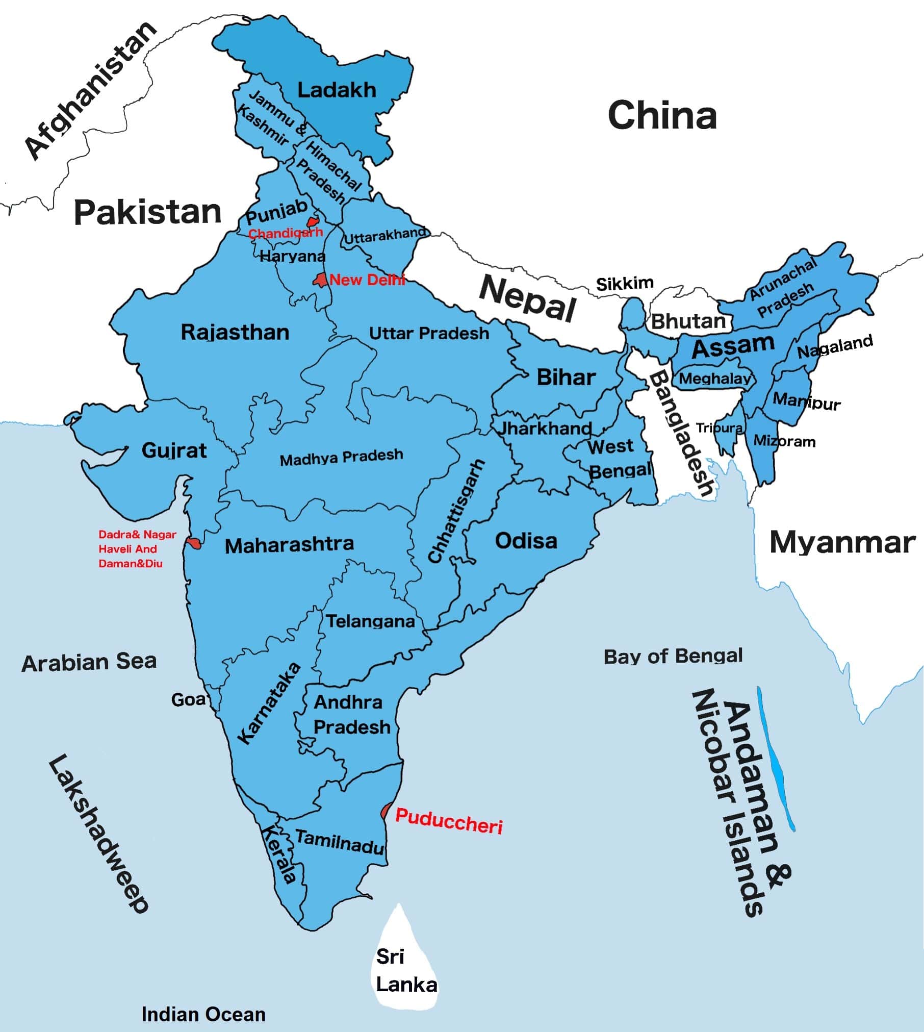
States Of India And Their Capitals
S.No | States Name | Capital |
1 | Andhra Pradesh | Amaravati |
2 | Arunachal Pradesh | Itanagar |
3 | Assam | Dispur |
4 | Bihar | Patna |
5 | Chhattisgarh | Raipur |
6 | Goa | Panaji |
7 | Gujarat | Gandhinagar |
8 | Haryana | Chandigarh |
9 | Himachal Pradesh | Shimla |
10 | Jharkhand | Ranchi |
11 | Karnataka | Bengaluru |
12 | Kerala | Thiruvananthapuram |
13 | Madhya Pradesh | Bhopal |
14 | Maharashtra | Mumbai |
15 | Manipur | Imphal |
16 | Meghalaya | Shillong |
17 | Mizoram | Aizawl |
18 | Nagaland | Kohima |
19 | Odisha | Bhubaneswar |
20 | Punjab | Chandigarh |
21 | Rajasthan | Jaipur |
22 | Sikkim | Gangtok |
23 | Tamil Nadu | Chennai |
24 | Telangana | Hyderabad |
25 | Tripura | Agartala |
26 | Uttar Pradesh | Lucknow |
27 | Uttarakhand | Dehradun (Winter) Gairsain (Summer) |
28 | West Bengal | Kolkata |
Union Territories Of India And Their Capitals
S.NO | Union Territories Names | Capital |
|---|---|---|
1 | Andaman and Nicobar Islands | Port Blair |
2 | Chandigarh | Chandigarh |
3 | Dadra & Nagar Haveli and Daman & Diu | Daman |
4 | Delhi | New Delhi |
5 | Jammu and Kashmir | Srinagar (Summer) Jammu (Winter) |
6 | Lakshadweep | Kavaratti |
7 | Pondicherry | |
8 | Ladakh | Leh |
FOR MORE INFORMATION ABOUT STATIC GK