
Table of Contents
Continent
Earth has seven main pieces of large, continuous, discrete masses of land, ideally separated by expanses of water. These pieces of land are known as the continent. The variation of continents’ sizes is huge. For example, the size of Asia is five times more than the size of Australia/Oceania. Asia, Africa, North America, South America, Antarctica, Europe and Australia/Oceania are the continents of the earth. In the above line, continents are listed in order of size. Sometimes, Europe and Asia are considered a single continent and called Eurasia because Asia and Europe are not separate pieces of land. But they are separate continents due to their societies, civilization developed separately.
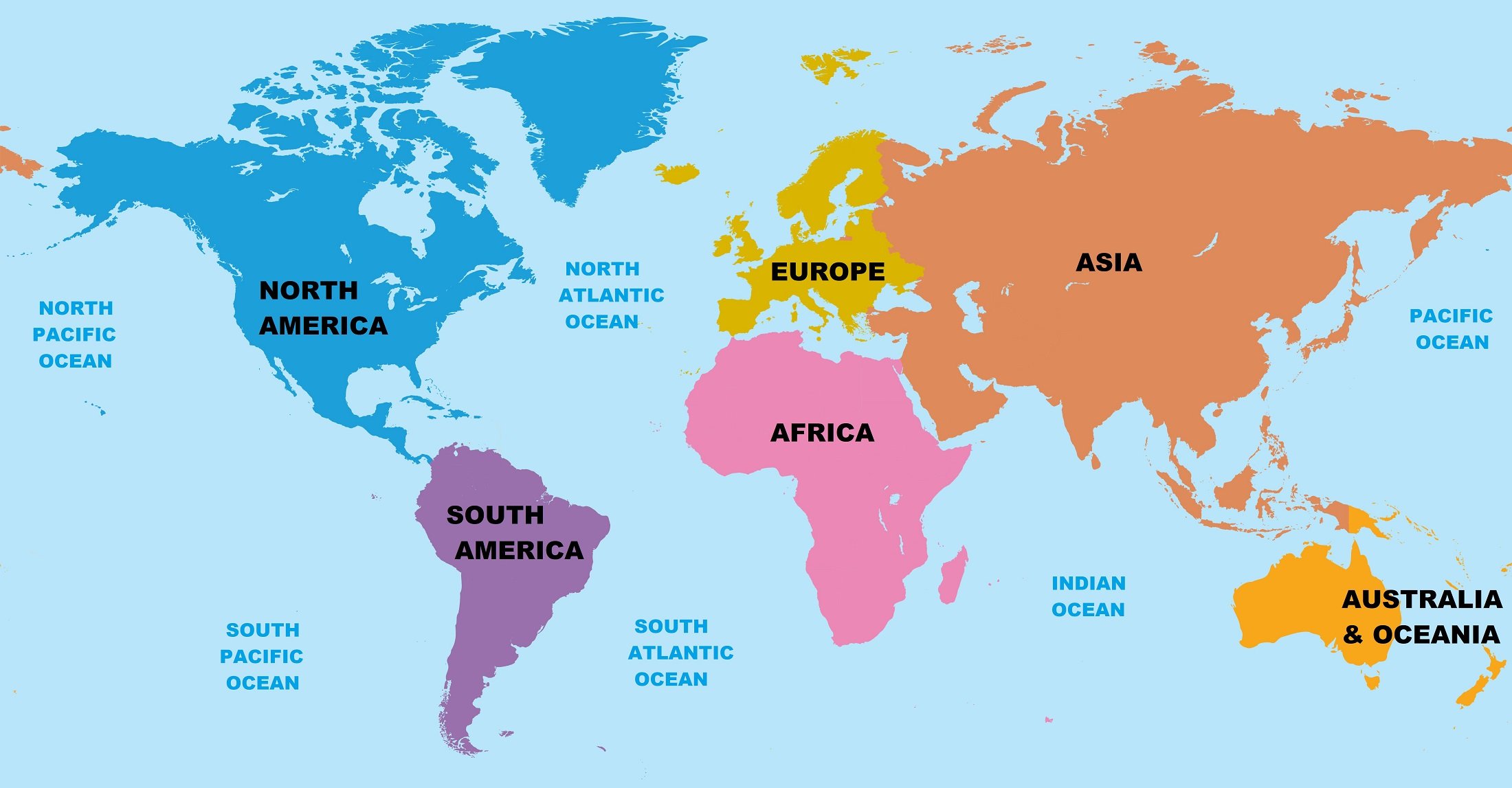
Usually, islands are also part of their nearest continent. For example, Greenland and all islands in the Caribbean Sea are usually considered part of North America. Only a very few islands are not part of any continent. The land area of all continents is approximately 148 million square km. The ocean covers almost three-fourth of Earth’s land surface. The area of the ocean is more than double the area of all the continents combined. All continents border at least one ocean. Coastlines do not indicate the actual boundaries of the continents. Continents are defined by their continental shelves. The continental shelf is a gently sloping area that extends outward from the beach far into the ocean. The continental shelf is part of the ocean but also part of the continent. The surface of the continents has changed many times because of erosion, weathering, build-up of sediment, mountain building, and continuous, slow movement of tectonic plates. Below we described all the continents one by one in detail.
Asia
Asia is the largest and most diverse continent of the earth. It is located in the Eastern and Northern Hemispheres. Asia covers an area of 44,614,000 square km, almost 30% of Earth’s total land area. The Asia continent shares borders with the Pacific Ocean to the east, the Indian Ocean to the south, the Arctic Ocean to the north, and Europe to the west. The separation of the border between Asia and Europe is not clearly physical and geographical. But the commonly accepted boundaries between Asia and Europe are the northern Ural Mountains in Russia, east of the Turkish straits, south of the Caspian and Black Seas. It is the most populous continent of the world. Earth’s sixty-percent population lives in Asia. More than one third of the population lives in India and China alone.
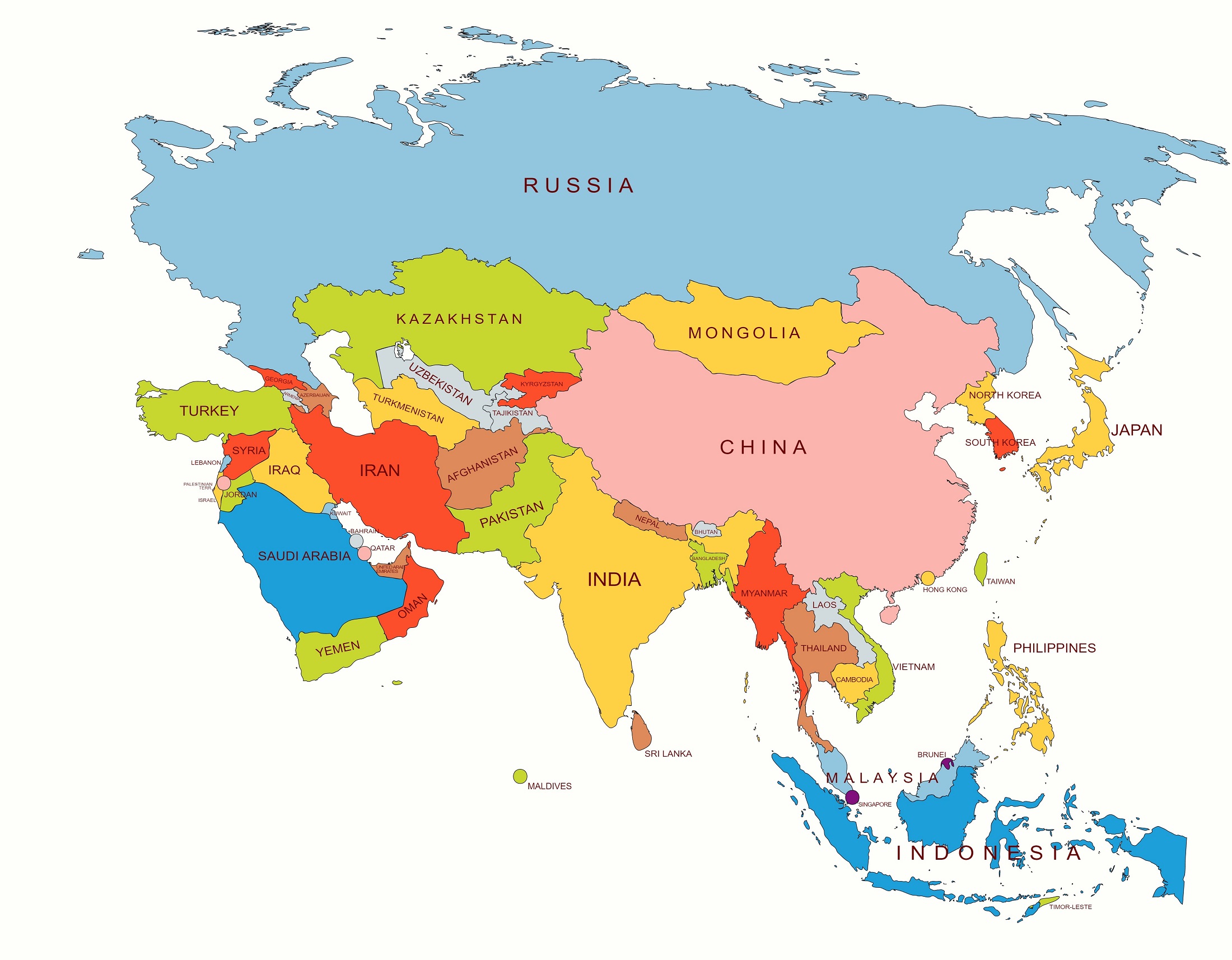
In Asia, there are 49 United Nations recognized countries (five of them, Georgia, Azerbaijan, Russia, Kazakhstan, and Turkey, are transcontinental countries lying partly in Europe), 1 United Nations observer state, 5 de facto states (not recognized by the United Nations) and 6 dependent territories of other countries. To know about the Asian countries with their capitals, go to the next chapter, the list of Asian countries with their capitals, and currencies. Asia continent includes many islands, some of them countries. Indonesia, Japan, Philippines, Maldives, and Taiwan are major island nations in Asia. The largest country of this continent is Russia and the smallest country is Maldives. Conventionally, there are six main geographical sub regions in Asia. These sub regions are the northern, western, central, eastern, southern, and southeast parts of Asia.
Below the table shown are general information about the Asia Continent.
| Area | 44,614,000 sq. km [Rank- 1st] |
| Population | 4.6 billion (2018) [Rank- 1st] |
| GDP (nominal) | $36.383 trillion (2021 estimate) [Rank- 1st] |
| GDP (Purchasing power parity) | $67.708 trillion (2021 estimate) [Rank- 1st] |
| GDP per capita | $7,850 (2021 estimate) [Rank- 4th] |
| Countries | 49 UN members, 1 UN Observer, 5 de facto states (non-UN states) |
| Dependent territories | 6 |
| Largest Country | Russia |
| Smallest Country | Maldives |
| Longest River | Yangtze River (6300 km) [China] |
| Largest Desert | Arabian Desert (2,330,000 sq. km) [Arabian Peninsula] |
| Highest Elevation (Above Sea Level in Meters) | Mount Everest (8849 m) [Tibet-Nepal] |
| Lowest Elevation (Below Sea Level in Meters) | Dead Sea (430 m) [Israel-Jordan] |
Asia is the birthplace of most of the world’s mainstream religions such as Hinduism, Zoroastrianism, Judaism, Jainism, Buddhism, Confucianism, Christianity, Islam, Sikhism, as well as many other religions.
Monsoon rains and snowmelt feed Asian rivers such as the Ganges, the Yellow River, the Mekong River, the Indus River, the Yangtze River, the Indus River, Brahmaputra, Amu Darya, and the Sutlej River etc. The Yangtze River in China is the longest river on the continent.
The largest desert of Asia is the Arabian desert. It is the fifth largest desert in the world and located in Western Asia. It stretches 2,330,000 square kilometers in the most part of the Arabian Peninsula.
Asia is the most mountainous of all the continents such as the Himalayas Mountains, Ural Mountains, Pamir Mountains, Hindu Kush, Aravalli Range etc. More than 50 of the highest peaks in the world are in Asia. Mount Everest is the highest peak of the earth which is situated in the Himalayan range.
Asia also contains the Earth’s lowest place on land. It is located on the shores of the Dead Sea between Israel and Jordan. The land there lies approximately 430 meters below sea level.
Africa
Africa is the second largest continent of the earth. It straddles the equator and the prime meridian, making it the only continent in the world which is situated in all four cardinal hemispheres. Africa covers an area of 30,370,000 square km, almost 20% of Earth’s total land area. The Africa continent shares borders with the Mediterranean Sea to the north, the Isthmus of Suez and Red Sea to the northeast, the Indian Ocean to the southeast, and the Atlantic Ocean to the west. It is connected to Asia by the Isthmus of Suez in Egypt and separated from Europe by the Mediterranean Sea. It is the second-most populous continent of the world. Earth’s seventeen-percent population lives in Africa.
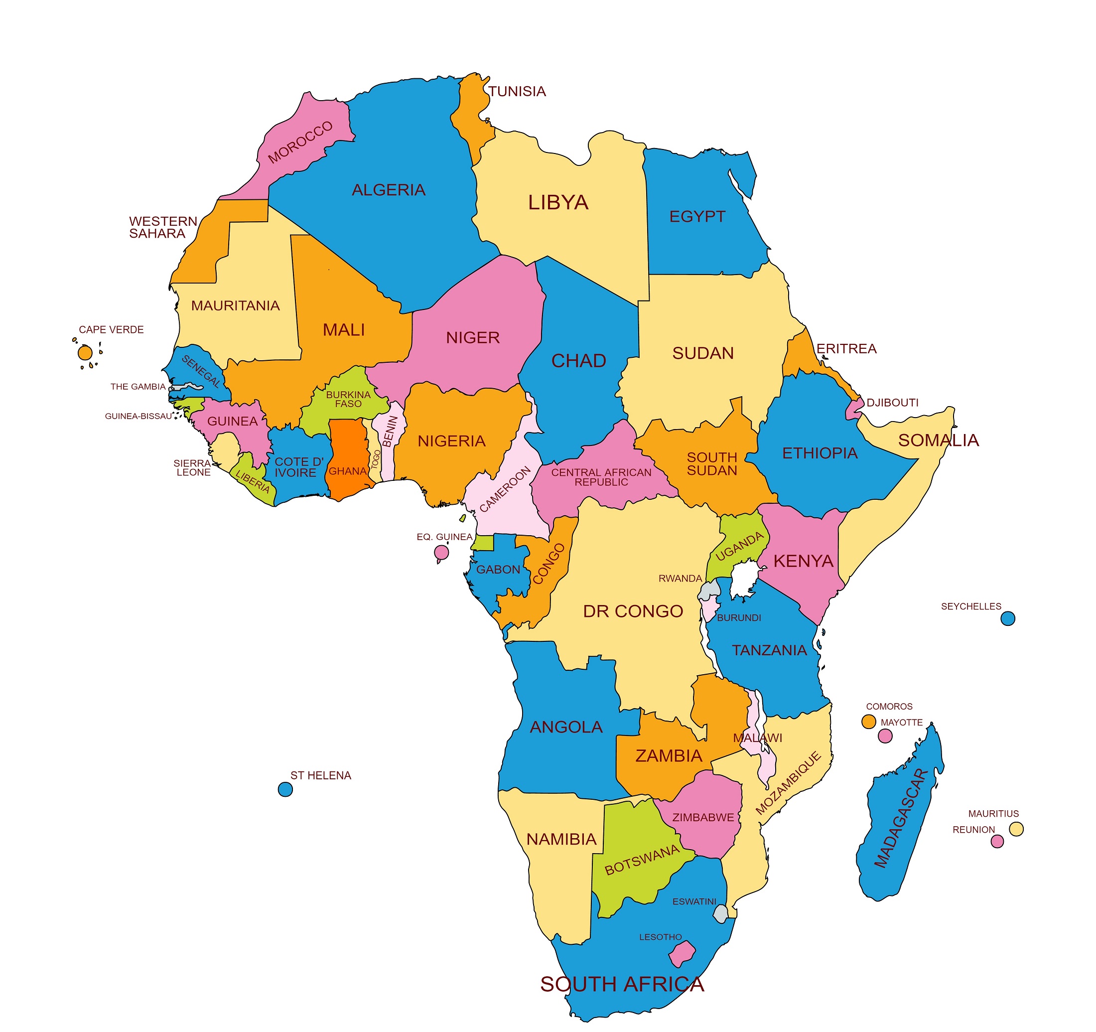
In Africa, there are 54 United Nations recognized countries, 2 de facto states (not recognized by the United Nations), and 11 dependent territories of other countries. To know about the African countries with their capitals, go to the next chapter, the list of African countries with their capitals, and currencies. The largest country of this continent is Algeria and the smallest country is Seychelles. The smallest nation on the continental mainland is The Gambia. In the African continent, Nigeria is the largest country by population. African countries cooperate with each other through the African Union, which is headquartered in Addis Ababa. Conventionally, there are five main geographical sub regions in Africa. These sub regions are the northern, western, central, eastern, and southern parts of Africa.
Below the table shown are general information about the Africa continent.
| Area | 30,370,000 sq. km [Rank- 2nd] |
| Population | 1.3 billion (2018) [Rank- 2nd] |
| GDP (nominal) | $2.601 trillion (2021 estimate) [Rank- 5th] |
| GDP (Purchasing power parity) | $6.92 trillion (2021 estimate) [Rank- 4th] |
| GDP per capita | $1860 (2021 estimate) [Rank- 6th] |
| Countries | 54 UN members, 2 de facto states (non-UN states) |
| Dependent territories | 11 |
| Largest Country | Algeria |
| Smallest Country | Seychelles |
| Longest River | Nile River (6650 km) |
| Largest Desert | Sahara Desert (9,200,000 sq. km)
|
| Highest Elevation (Above Sea Level in Meters) | Mount Kilimanjaro (5895 m) [Tanzania] |
| Lowest Elevation (Below Sea Level in Meters) | Lake Assal (156.1 m) [Djibouti] |
The top half of the African continent is mostly dry, hot desert. The Sahara Desert, which covers much of North Africa, is the world’s largest hot desert. The middle area has savannas or flat, grassy plains. This region is home to wild animals such as lions, hyenas, cheetahs, giraffes, elephants, and wildebeests. The central and southern areas of Africa are dominated by rainforests.
Mostly, monsoon rains and snowmelt feed Africa rivers such as the Nile River, the Congo River, the Zambezi River, the Niger River, the Orange River, the Benue River, the Kagera River, and the Uele River etc. The Nile River is the longest river of the African continent and also the world’s largest river.
The largest desert of Africa is the Sahara Desert. It is the third largest desert in the world and located in Northern Africa. It stretches 9,200,000 square kilometers in the most part of Northern Africa.
In Africa, there are so many mountains and mountain ranges such as Mount Kilimanjaro, Mount Kenya, Mount Meru, Mount Elgon, Mount Stanley, Mount Karisimbi, and Mount Guna etc. Mount Kilimanjaro is the highest peak of the African continent, which is situated in the Eastern Rift mountains. It is also the highest single free-standing mountain in the world.
Lake Assal is a saline lake that lies 156.1 meters below sea level in the Afar Triangle, making it the lowest point on land in Africa and the third lowest point on Earth after the Sea of Galilee and the Dead Sea. It is situated in central Djibouti.
North America
North America is the third largest continent of the earth. It is located entirely within the Northern Hemisphere and almost entirely within the Western Hemisphere. The North America continent shares borders with the Arctic Ocean to the north, the Atlantic Ocean to the east, the Caribbean Sea and the South America continent to the southeast, and the Pacific Ocean to the south and west. It covers an area of 24,709,000 square km, almost 16.5% of Earth’s total land area. It is the fourth most populous continent of the world. Earth’s eight-percent population lives in North America.
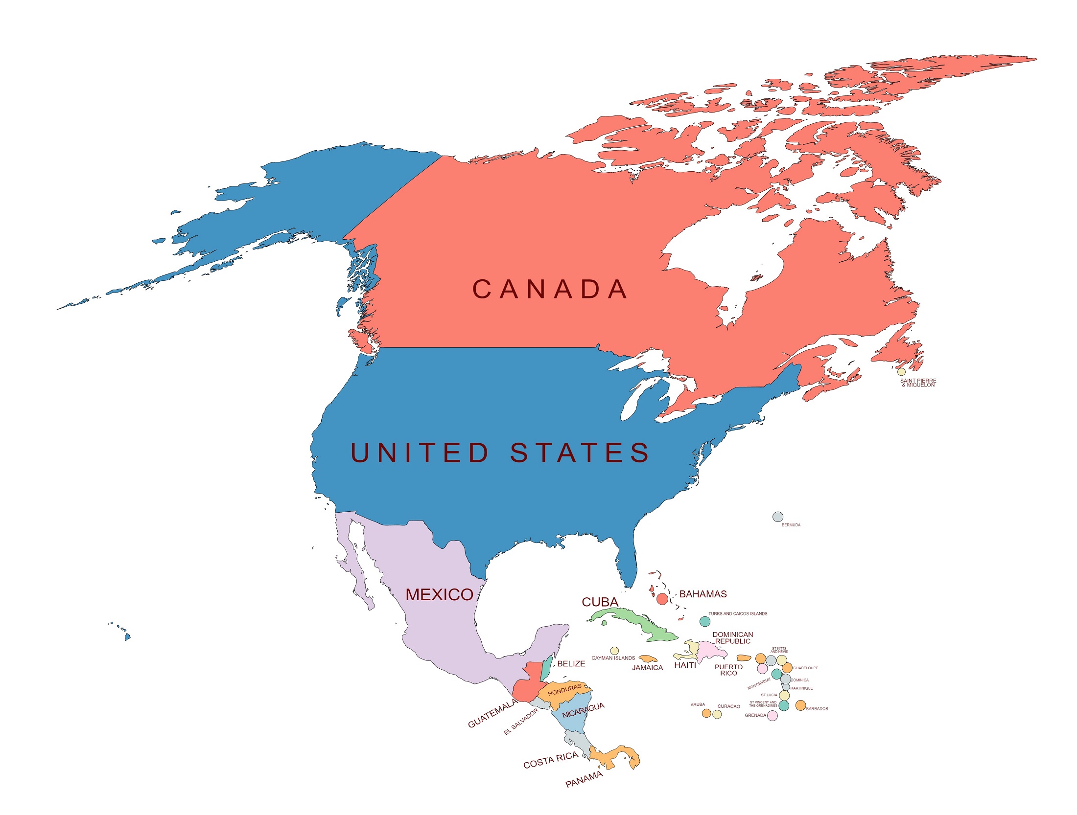
In North America, there are 23 United Nation recognized countries, 9 dependent territories of other countries, and 16 integral territories primarily of non- North American countries. To know about the North America countries with their capitals, go to the next chapter, the list of North America countries with their capitals, and currencies.
The North America continent includes many islands, some of them countries such as Jamaica, Cuba, Grenada, Barbados, Bahamas, Haiti, Dominica etc. This continent includes the enormous island of Greenland in the northeast. Greenland is the world’s largest island. Despite its name, Greenland is mostly covered with ice.
Below the table shown are general information about the North America continent.
| Area | 24,709,000 square km [Rank- 3rd] |
| Population | 580 million (2018) [Rank- 4th] |
| GDP (nominal) | $24.88 trillion (2021 estimate) [Rank- 2nd] |
| GDP (Purchasing power parity) | $26.55 trillion (2021 estimate) [Rank- 2nd] |
| GDP per capita | $49,430 (2021 estimate) [Rank- 2nd] |
| Countries | 23 UN member |
| Dependent territories | 24 |
| Largest Country | Canada |
| Smallest Country | Saint Kitts and Nevis |
| Longest River | Missouri River (3767 km) [United States of America] |
| Largest Desert | Great Basin Desert (492,098 sq. km) [United States of America] |
| Highest Elevation (Above Sea Level in Meters) | Denali (or Mount Mckinley) (6190 m) [Alaska] |
| Lowest Elevation (Below Sea Level in Meters) | Death Valley’s Badwater Basin (86 m) [California] |
The largest country of this continent is Canada and the smallest country is Saint Kitts and Nevis. Conventionally, there are three main geographical sub regions in the North America continent. These sub regions are Northern America, Central America, and the Caribbean.
The name AMERICA in the Mayan language means a country of perpetually strong wind or the Land of the Wind.
In the past, the North America and South America continent was colonized by Europe. So the most of the North and South American speak European languages such as English, French, or Spanish, and their cultures commonly reflect Western traditions. However, in some parts of Canada, the United States, Mexico, and Central America, there are indigenous populations continuing their cultural traditions and speaking their own languages. The North America and South America continent is connected at the Isthmus of Panama. It is also well-known as the Isthmus of Darien.
Monsoon rains and snowmelt feed North America rivers such as the Missouri, the Mississippi River, the Columbia River, the Colorado River, the Hudson River, the Ohio River, the Snake River, and the Yukon River etc. In the North America continent, the Missouri River is the longest river.
The largest desert of North America is the Great Basin Desert. It is the tenth largest desert in the world. It is a temperate desert with hot, dry summers and snowy winters. It stretches 492,098 square kilometers in the United States of America.
In the North America continent, there are so many mountains and mountain ranges such as Mount Whitney, Mount Elbert, Mount Rainier, Mount Foraker, Mount Logan, Mount Mitchell, Mount Guna, and Denali etc. Mount McKinley is the highest peak of the North America continent. It is located in the Alaska Range in Alaska. It is also known as Denali.
Death Valley’s Badwater Basin is the lowest point in the North America continent. It is situated in Death Valley National Park in California. The land there lies approximately 86 meters below sea level.
South America
South America is the fourth largest continent of the earth. It is located entirely in the Western Hemisphere and mostly in the Southern Hemisphere, with a very small portion in the Northern Hemisphere. The South America continent shares borders with the Pacific Ocean to the west, the Atlantic Ocean to the east and north, the Caribbean Sea and North America Continent to the northwest, and the Southern (Antarctic) Ocean to the south. It covers an area of 17,840,000 square km, almost 11.98% of Earth’s total land area. It is the fifth most populous continent of the world. Earth’s six-percent population lives in South America.
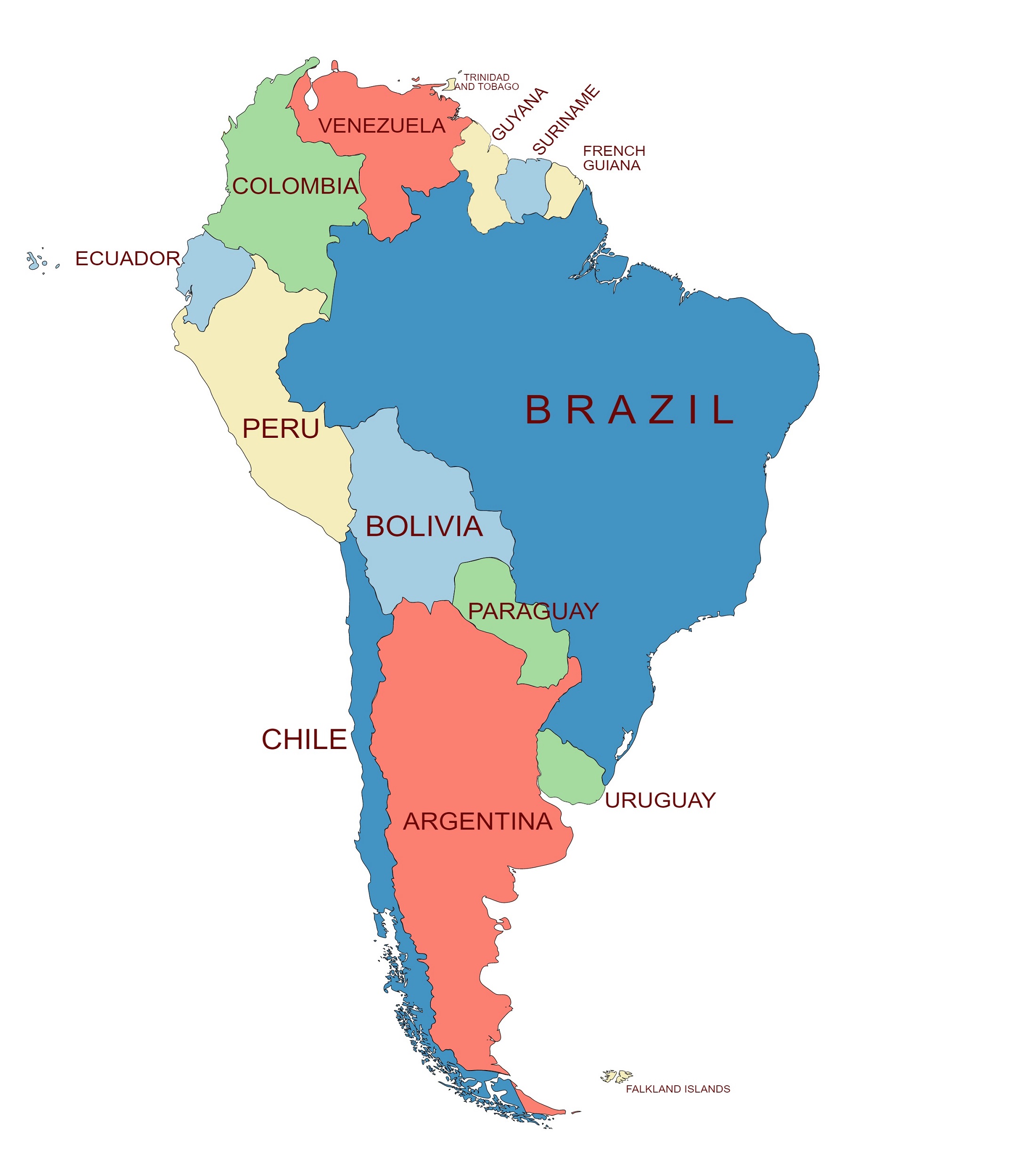
In South America, there are 12 United Nation recognized countries, 3 dependent territories of other countries, and 1 integral territory primarily of non- South American countries. To know about the South America countries with their capitals, go to the next chapter, the list of South America countries with their capitals, and currencies. The largest country of this continent is Brazil and the smallest country is Suriname. Brazil is also the most populous South America country.
Below the table shown are general information about the South America continent.
| Area | 17,840,000 square km [Rank- 4th] |
| Population | 420 million (2018) [Rank- 5th] |
| GDP (nominal) | $3.019 trillion (2021 estimate) [Rank- 4th] |
| GDP (Purchasing power parity) | $6.53trillion (2021 estimate) [Rank- 5th] |
| GDP per capita | $6,720 (2021 estimate) [Rank- 5th] |
| Countries | 12 UN members |
| Dependent territories | 4 |
| Largest Country | Brazil |
| Smallest Country | Suriname |
| Longest River | Amazon River (6,992 km)
|
| Largest Desert | Patagonian Desert (673,000 sq. km) [Argentina] |
| Highest Elevation (Above Sea Level in Meters) | Mount Aconcagua (6961 m) [Argentina-Chile] |
| Lowest elevation (Below Sea Level in Meters) | Laguna del Carbón (105 m) [Argentina] |
In the past, the North America and South America continent was colonized by Europe. So, the most of the North and South American speak European languages such as English, French, or Spanish, Portuguese and their cultures commonly reflect Western traditions. However, in some parts of the South America continent there are indigenous populations continuing their cultural traditions and speaking their own languages. The South America and North America continent is connected at the Isthmus of Panama. It is also well-known as the Isthmus of Darien.
Monsoon rains, snowmelt and tropical rainforest feed South America rivers such as the Amazon River, the Parana River, the Orinoco River, the Paraguay River, and the Uruguay River etc. In the South America continent, the Amazon River is the longest river. It is the second largest river in the world. In volume, the Amazon is the largest river in the world.
The South America continent is also home of the world’s highest waterfall, Angel Falls, in the country of Venezuela and the highest single drop waterfall, Kaieteur Falls in Guyana.
The largest desert of South America is the Patagonian Desert. It is the eight-largest desert in the world. It is a cold winter desert; the average temperature is 3°C. It stretches 673,000 square kilometers in Argentina.
In the South America continent, there are so many mountains and mountain ranges such as Aconcagua, Mercedario, Huascaran, Monte Pissis, Tupungato, Cotopaxi, Misti, and the Andes mountains ranges etc. Aconcagua is the highest peak of the South America continent. It is located in the Andes mountains range in Argentina.
Laguna del Carbón is the lowest point in the South America continent. It is situated in Santa Cruz Province, Argentina. The land there lies approximately 105 meters below sea level.
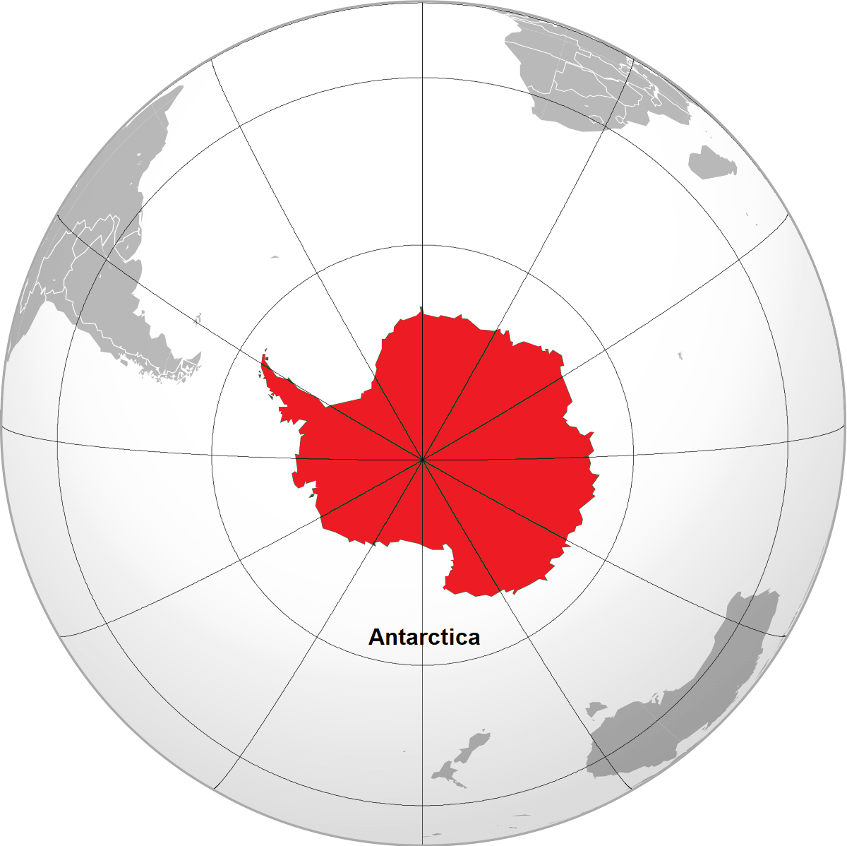
Antarctica
Antarctica is the fifth largest continent of the earth. It is Earth’s southernmost continent. It is situated in the Antarctic region of the Southern Hemisphere, almost entirely south of the Antarctic Circle, and is surrounded by the Southern Ocean. It covers an area of 14,200,000 square km, almost 9.6 % of Earth’s total land area. It is nearly twice the size of Australia. Almost 98 % of the Antarctica land is covered by ice, and the average thickness of ice is 1.9 kilometers except the McMurdo Dry Valleys and the northernmost of the Antarctic Peninsula.
Antarctica is the windiest, driest, and iciest place on Earth. Most of Antarctica is a polar desert, with annual precipitation of 200 mm (7.9 in) along the coast and far less inland. Antarctica is the largest polar desert of the world. The climate of Antarctica makes it impossible to support agriculture or a permanent civilization. Temperatures in Antarctica, much lower than Arctic temperatures, plunge lower than -73 degrees Celsius. It has no permanent human population. People who work there are scientific researchers and support staff, such as pilots and cooks.
Below the table shown are general information about the Antarctica continent.
| Area | 14,200,000 square km [Rank- 5th] |
| Population | 1,000 to 5,000 (seasonal) |
| Longest River | Onyx River (32 km) |
| Highest elevation (Above Sea Level in Meters) | Vinson Massif (4892 m) |
| Lowest elevation (Below Sea Level in Meters) | Denman Glacier (3500 m) |
Antarctica does not have any country. It is governed by parties to the Antarctic Treaty System. This treaty prohibits military activities, mineral mining, nuclear explosions and nuclear waste disposal. It supports scientific research and protects the continent’s ecology. However, scientific groups from different countries inhabit the research stations. McMurdo Station is operated by the United States, which is the largest station of Antarctica. Vostok Station, where the coldest temperature on Earth was recorded, is operated by Russia.
There are a number of rivers and lakes in Antarctica. The longest river is the Onyx. The largest lake, Vostok, is one of the largest subglacial lakes in the world.
In the Antarctica continent, there are so many mountains such as Vinson Massif, Mount Erebus, Mount Kirkpatrick, Mount Sidley, and Mount Tyree etc. Vinson Massif is the highest peak of the Antarctica continent. It is located in the Sentinel Range of the Ellsworth Mountains. In the Antarctica continent, Mount Erebus on Ross Island is the world’s southernmost active volcano.
Denman Glacier is the lowest point in the Antarctica continent. The land there lies approximately 3500 meters below sea level. This is also the lowest place on Earth not covered by the ocean (although it is covered by ice).
Europe
Europe is the second smallest continent of the earth. It is located entirely in the Northern Hemisphere and mostly in the Eastern Hemisphere. The European continent shares borders with the Arctic Ocean to the north, the Atlantic Ocean to the west, the Mediterranean Sea to the south, the Black Sea to the southeast and Asia to the east. The separation of the border between Europe and Asia is not clearly physical and geographical. But the commonly accepted boundaries between Asia and Europe are the northern Ural Mountains in Russia, east of the Turkish straits, south of the Caspian and Black Seas. It covers an area of 10,180,000 square km, almost 6.8% of Earth’s total land area. It is the third most populous continent of the world. Earth’s ten-percent population lives in Europe.
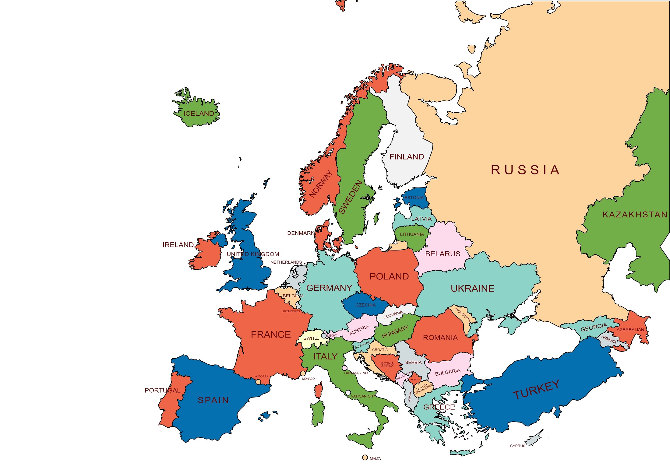
In Europe, there are 50 United Nation recognized countries, 3 special territories with internal sovereignty, 6 de facto states (not recognized by the United Nations), and 6 dependent territories of the other countries. To know about the European countries with their capitals, go to the next chapter, the list of European countries with their capitals, and currencies. The largest country of this continent is Russia and the smallest country is Vatican City. Vatican City is a tiny territory in the center of Rome. Russia, Azerbaijan, Kazakhstan, Turkey, and Georgia are transcontinental countries partially located in both Europe and Asia. Politically, Cyprus and Armenia are considered European countries though they are located in West Asia territory. Conventionally, there are four main geographical sub regions in Europe. These sub regions are the Northern, Western, Eastern, and Southern parts of Europe.
Below the table shown are general information about the Europe continent.
| Area | 10,180,000 square km [Rank- 6th] |
| Population | 750 million (2018) [Rank- 3rd] |
| GDP (nominal) | $23.614 trillion (2021 estimate) [Rank- 3rd] |
| GDP (Purchasing power parity) | $30.573 trillion (2021 estimate) [Rank- 2nd] |
| GDP per capita | $31,020 (2021 estimate) [Rank- 3rd] |
| Countries | 50 UN members, 6 de facto states (non-UN states) |
| Dependent territories | 6 |
| Largest country | Russia |
| Smallest country | Vatican City |
| Longest river | Volga River (3531 km) [Russia] |
| Highest elevation (Above Sea Level in Meters) | Mount Elbrus (5,642 m) [Russia] |
| Lowest elevation (Below Sea Level in Meters) | Caspian Sea (28 m)
|
Monsoon rains and snowmelt feed European rivers such as the Volga River, the Danube River, the Rhine River, the Douro River, the Seine River, the Elbe River, and the Vistula River etc. In the European continent, the Volga River in Russia is the longest river.
In Europe, there are so many mountains such as Mount Elbrus, Mont Blanc, Matterhorn, Grossglockner, Scottish Highlands, Monte Rosa, and Kebnekaise etc. Mount Elbrus is the highest peak of the Russia and Europe continent, which is in the western part of the Caucasus and is the highest peak of the Caucasus Mountains.
The Caspian Sea and its shores is the lowest point in Europe. The land there lies approximately 28 meters below sea level and
Also, the Azerbaijan capital Baku is located 28 meters (92 ft) below sea level, which makes it the lowest-lying national capital in the world and also the largest city in the world located below sea level. Azerbaijan is a transcontinental country partially located in both Europe and Asia, hence do not consider it the lowest point of Europe.
Oceania
Oceania is the smallest continent of the earth. It spans the Eastern and Western Hemispheres. This continent is also known as the Australia continent. It is surrounded by the Indian, Antarctica, and Pacific Oceans. It covers an area of 8,525,989 square km, almost 5.8% of Earth’s total land area. It extends to New Guinea in the west, the Hawaiian Islands in the northeast, Easter Island and Isla Salas y Gomez in the east, the Bonin Islands in the northwest, and Macquarie Island in the south. The Oceania continent is the second-smallest in population after Antarctica. Earth’s 0.54 % population lives in Oceania.
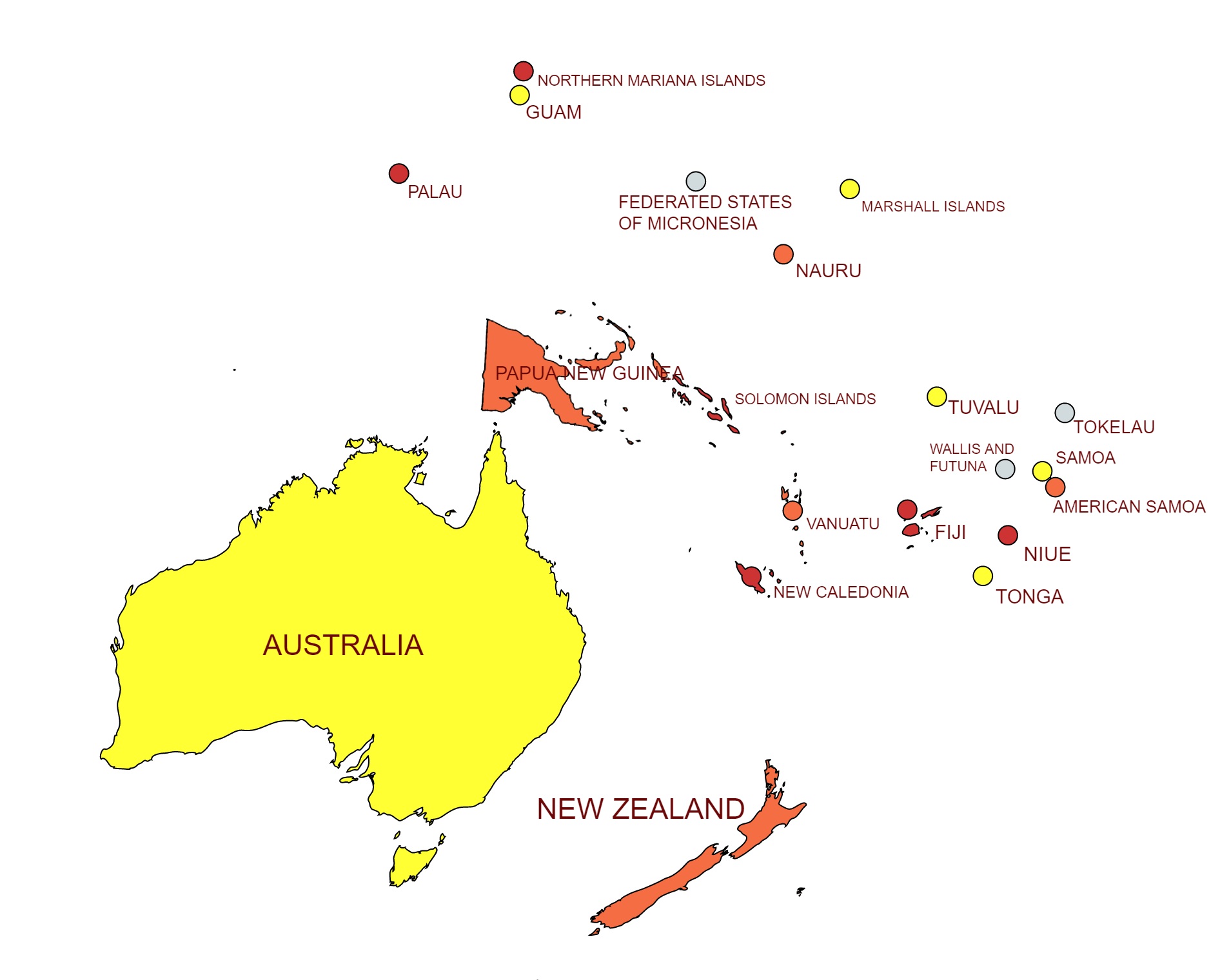
In the Oceania continent, there are 14 United Nation recognized countries and 28 non-sovereign territories. To know about the Oceania countries with their capitals, go to the next chapter, the list of Oceania countries with their capitals, and currencies. Conventionally, there are four main geographical sub regions in the Oceania continent. These sub regions are Australasia, Melanesia, Micronesia, and Polynesia. The Oceania continent includes thousands of tiny islands, some of them also countries such as Fiji, Nauru, New Zealand, Palau, Tuvalu etc. The largest country of this continent is Australia and the smallest country is Nauru.
Below the table shown are general information about the Oceania continent.
| Area | 8,525,989 square km [Rank- 7th] |
| Population | 42 million (2018) [Rank- 6th] |
| GDP (nominal) | $1.894 trillion (2021 estimate) [Rank- 6th] |
| GDP (Purchasing power parity) | $1.693 trillion (2021 estimate) [Rank- 6th] |
| GDP per capita | $54,690 (2021 estimate) [Rank- 1st] |
| Countries | 14 UN members |
| Dependent territories | 28 |
| Largest country | Australia |
| Smallest country | Nauru |
| Longest river | Murray River (2508 km) [Australia] |
| Largest desert | Victoria Desert (422,466 sq. km) [Australia] |
| Highest elevation (Above Sea Level in Meters) | officially Mount Kosciuszko (2,228 m) [Australia] And non -officially Mount Wilhelm (4509 m) [Papua New Guinea] |
| Lowest elevation (Below Sea Level in Meters) | Lake Eyre (15.8 m) [Australia] |
Monsoon rains and snowmelt feed Oceania rivers such as the Murrumbidgee River, the Fly River, the Murray River, the Darling River, the Sepik River, and the Flinders River etc. The Murray River in Australia is the longest river in the Oceania continent.
The largest desert of Oceania is the Great Victoria Desert. It stretches 422,466 square kilometers in Western Australia and South Australia. But in Australia there are so many deserts, they are combined called Deserts of Australia.
In Oceania, there are so many mountains such as Mount Kosciuszko, Mount Wilhelm, Aoraki / Mount Cook, Mount Tabwemasana, Mount Popomanaseu, Mount Tomanivi, and Mount Taranaki etc. Mount Wilhelm is the highest peak of the Papua New Guinea and Oceania continent. It is part of the Bismarck Range. But Mount Wilhelm is not officially recognized as the highest peak point of the Oceania continent. The officially highest peak point of the Oceania continent is Mount Kosciuszko. It is located on the Main Range of the Snowy Mountains in Kosciuszko National Park in Australia.
Lake Eyre is the lowest point in Oceania. It is also known as Kati Thanda. The land there lies approximately 15.8 meters below sea level. It is the largest lake in Australia covering an area up to 9,500 square kilometers.
FOR MORE INFORMATION ABOUT STATIC GK